


Waviness
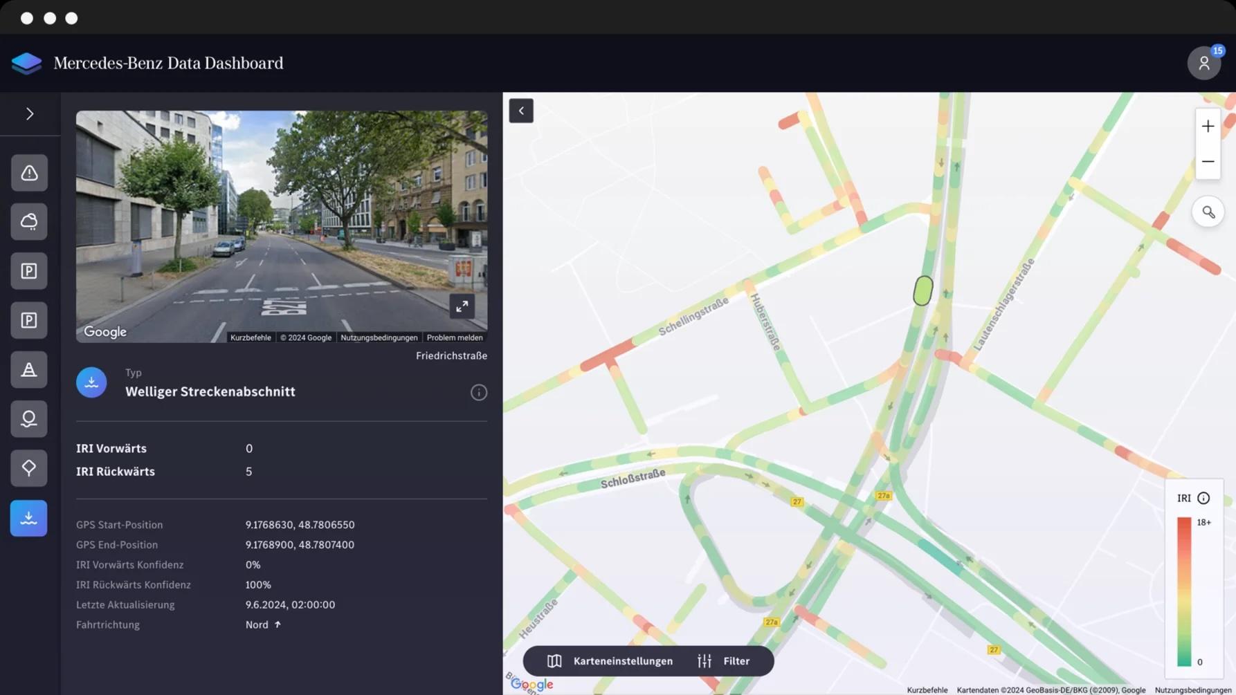
Using Mercedes-Benz fleet data, this product assesses road waviness for entire street segments based on IRI10 and RMSE, bridging gaps between standard measurement cycles.
Keep an eye on the road quality in your region
Profile evenness is one of the key quality characteristics of roads. It influences driving comfort and safety.
This is why longitudinal waviness is a standard measurement method for road authorities to assess road pavement quality. In many countries, road authorities determine the longitudinal waviness of roads every 4 to 5 years with high-resolution measurements by engineering companies. It is a necessary but cost-intensive process. With Mercedes‑Benz Data, we can optimally supplement the regular measurements. In this way, road authorities gain insight into road surface unevenness between the high-resolution measurements – and this is automated by near real-time data from vehicles that are already driving on roadways: the networked Mercedes‑Benz vehicle fleet. The data is provided in accordance with the ISO International Roughness Index 10 (IRI10) and Root Mean Square Error (RMSE) standard.
Get in touch with us!
Speak with our experts to explore Wainess and get the answers you need.
Contact usWhat data is included?
Whether cities and municipalities, road authorities or road maintenance companies: The Waviness dataset supplements data from standing standard measurement procedures to compensate for the "data-less" time between measurements. The data product assesses road waviness for whole street segments based on the International Roughness Index 10 (IRI10) and Root Mean Square Error (RMSE).
-
Level of longitudinal waviness (IRI10)
-
Root Mean Square Error (RMSE)
-
GPS position
-
Heading (in compass direction)
-
Time stamp of last line string traverse
-
Confidence level (0% to 100%)
Your advantages at a glance
Optimize your road quality by incorporating the longitudinal waviness information generated by the Mercedes‑Benz vehicle fleet into your consideration.
-
Create a digital twin of road surfaces
Developing a digital twin of road surfaces enables precise monitoring and maintenance, enhancing road safety and longevity.
-
Insights into the development of road quality
Transparent reports provide valuable insights into the development of road quality and support effective maintenance strategies.
-
Optimized maintenance in terms of budget planning and allocation
A transparent overview of the condition of road surfaces enables optimised maintenance through more precise budget planning and allocation.
-
Knowledge enhancement for future road projects
Up-to-date knowledge and new technologies are essential in order to design future road projects efficiently and sustainably.
More safety and a head start in knowledge using a three-step approach
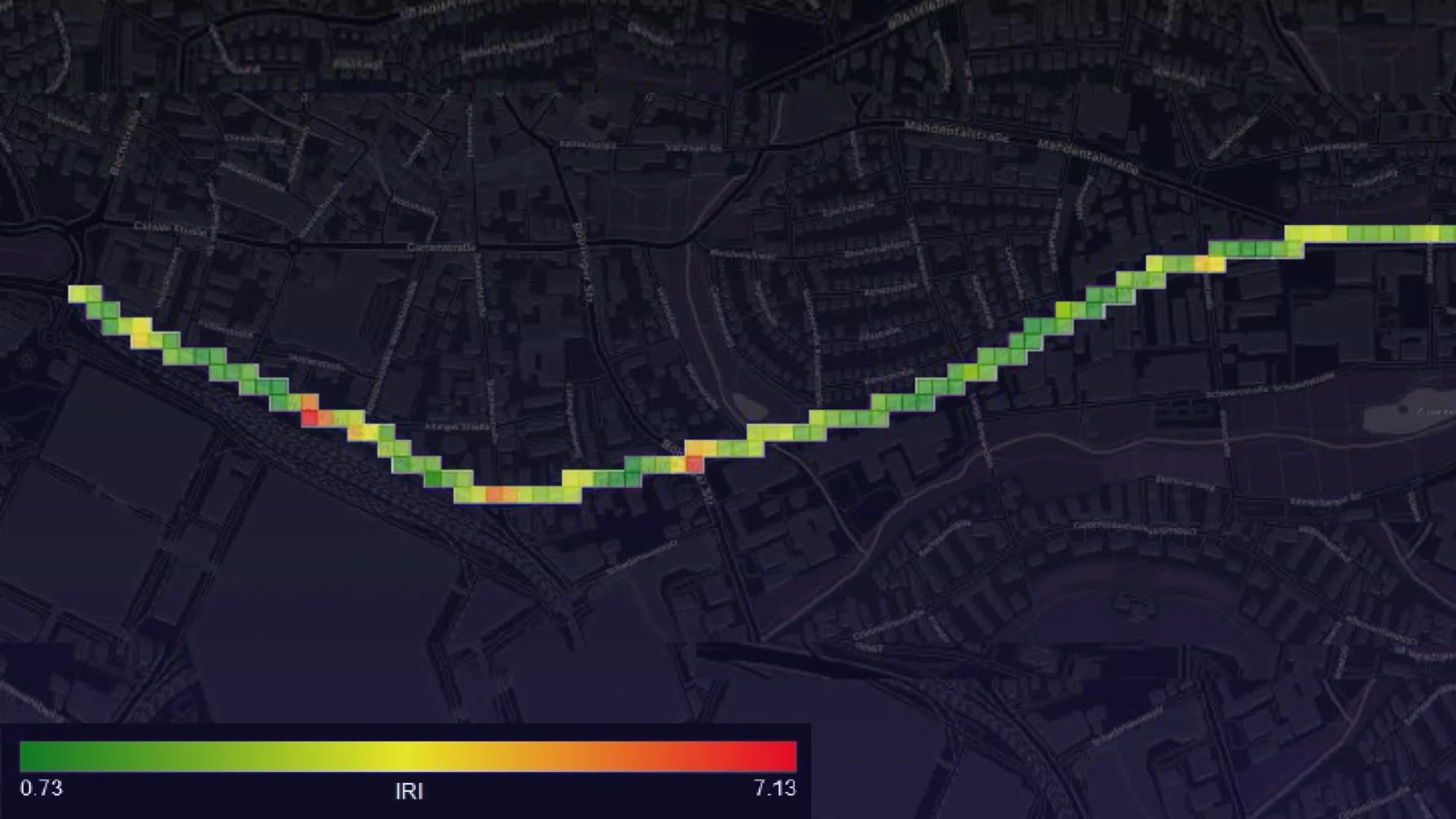
We use a combination of different sensors and signals from our Mercedes‑Benz vehicle fleet to detect longitudinal road waves according to the International Roughness Index 10 (IRI10) and Root Mean Square Error (RMSE). In addition to recording the actual situation, we can also evaluate the development over a time period.
Reliable data is determined using a three-stage approach:
1. Data collection in a defined period of time
For the specific use case of street waviness damages in a certain region, we only collect the specifically required data, provided that the vehicle drivers have given their consent to provide the data. The connected Mercedes‑Benz vehicle fleet provides an excellent basis for covering many regions worldwide.
The data is then sent from the Mercedes‑Benz vehicle fleet to the Mercedes‑Benz backend for the defined period. The waviness is calculated in the backend cloud on the basis of various factors. The calculation includes the shock absorber level, the acceleration in combination with the speed and the GPS position.
2. Multiple passing of sections for higher accuracy over time
Based on multiple passes by additional vehicles, higher accuracy of IRI10 and RMSE is achieved. However, we disguise the timestamp to a certain extent to make tracking of a single person impossible for privacy reasons.
3. Data visualization, provision and tracking of development over time
Finally, the IRI10 and RMSE values can be retrieved via our pull-API.
Arrange your personal consultation!
Our connectivity specialists will advise you on potential use cases and help you explore how Waviness can support your business or solution.